
You find a block a few streets back from the water on the NSW coast. The numbers work. Then your planner asks whether you have checked the acid sulfate soils mapping, and whether your excavation will go below the watertable.
That question decides whether this site is straightforward or whether it carries an assessment, a management plan, a disposal problem and a supervision obligation that all sit in front of your consent.
The deal question: is the soil harmless until you dig?
Usually yes, and that is what makes the risk easy to miss. NSW Environment and Heritage explains that acid sulfate soils are natural sediments containing iron sulfides, and that left undisturbed they do not present any risk. Expose them to air and the sulfides react with oxygen to create sulfuric acid, which makes metals such as iron and aluminium more soluble and able to be released in toxic amounts. The same page records that sulfuric acid can corrode concrete, iron, steel and some aluminium alloys.
So the question for your deal is not whether the soil exists. It is what your works do to it.
Where these soils actually sit, and where they do not
They are common along the NSW coast and found in every coastal estuary. Because of their estuarine origin they are usually found at elevations less than one metre above sea level, and they underlie floodplains, levees and backswamps. The published figure is that they may affect more than 260,000 hectares of land. The largest areas are the coastal floodplains of northern New South Wales, particularly the Tweed, Richmond, Clarence, Macleay and Hastings rivers, with the Hunter and Shoalhaven also notable.
The page is equally clear that drainage and excavation of these soils remains a current issue for urban development, infrastructure and sand mining. This is not a historic problem that has been solved.
What triggers the assessment and the management plan
The NSW Acid Sulfate Soils Manual sets out the trigger in two parts. The first is oxidisable sulfur at or above the Action Criteria in Table 4.4, which is a sampling result. The second is groundwater. The manual states that the second principal issue with regard to triggering the need for a management plan and development consent is whether the groundwater level is likely to be lowered and by how much, and that if the concentration meets or exceeds the action criteria then an acid sulfate soils management plan must be prepared and development consent must be obtained from council.
The manual also explains that works which lower groundwater levels include excavation to or below the watertable and dewatering of construction sites. It assigns a figure of 500 metres from Class 1-4 land as the threshold beyond which proposed works in Class 5 land will not trigger the local environmental plan, because the concern in Class 5 is the potential to alter groundwater levels in adjacent higher-risk land.
Read that back into a project. A basement, a semi-basement, a stormwater basin, deep services trenches, a driveway cut, or a subdivision that needs a new drainage line can all be the event that matters.
What it costs, and where the cost hides
Three cost lines appear, and only one of them is obvious.
- Assessment and reporting. Sampling to the required depths, laboratory analysis against the Action Criteria, and a management plan prepared by a qualified consultant.
- Construction method and materials. Corrosion resistance, foundation design and the sequencing of earthworks and drainage can all change once the soil is in scope.
- Disposal. The NSW EPA Waste Classification Guidelines define virgin excavated natural material as natural material that does not contain sulfidic ores or soils. Material that fails that test does not travel as clean fill, so it attracts different handling and a different gate fee.
National guidance through the Australian and New Zealand Guidelines for Fresh and Marine Water Quality records that acid sulfate soil can lead to reduced pH, decreased oxygen concentration in water and the release of heavy metals such as cadmium and lead and metalloids such as arsenic, and that acid and contaminants enter waterways when soils are rewetted. That is why the sequencing of earthworks and the control of water leaving the site are conditions rather than choices.
The trap: assuming the drainage channel is a given
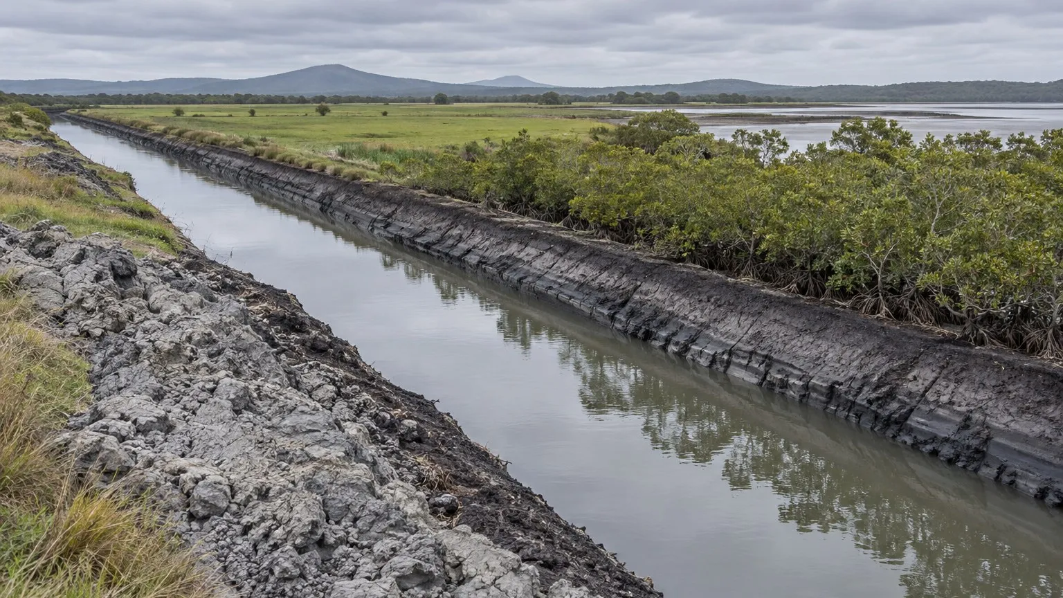
The quiet trap on coastal sites is older drainage and flood mitigation works. Major drainage works were built on floodplains from the Tweed to the Shoalhaven from the late 1800s until the mid-1970s, and they lowered watertables across land that now carries housing. A site can look dry and settled while the material beneath it sits in a permanently lowered watertable that your excavation will disturb further. Existing drains are also the route by which disturbed acid and metals reach a waterway, which brings the drainage design and the receiving environment into the same assessment.
The second trap is the reverse: treating a mapped risk class as a conclusion. Mapping identifies probability and risk; the manual requires sampling to establish whether the Action Criteria are exceeded. Neither the mapping nor a neighbouring approval answers it for your site.
The site test a student would run, in order
- Check the mapping and the planning instrument. Identify the risk class and read the acid sulfate soils clause in the applicable local environmental plan before you design anything.
- Establish the excavation profile. How deep, where, and does any part of the works reach or fall below the watertable — including services, drainage and any basin or basement.
- Ask whether groundwater will be lowered, even indirectly, and by how much. The manual treats this as the second trigger, so answer it explicitly rather than by assumption.
- Commission sampling to the required depths, designed by a consultant, and interpret the results against the Action Criteria.
- Price the method, not just the report. Corrosion, foundation design, treatments, disposal classification and gate fees all belong in the feasibility with a contingency.
- Map the programme. Assessment, management plan, any concurrence or condition, and construction-phase monitoring obligations.
What this does to the offer
Run the feasibility twice: once with the site cleared of acid sulfate soils scope, and once with the assessment, the management plan, the disposal route and the supervision built in. If only the second version works, that second version is your real deal, and the difference belongs in your offer and your contingency rather than in a hope that the condition will not be imposed. Coastal sites are also where a condition can add weeks to a programme, and weeks are holding costs.
Practical next steps
You are not expected to solve this yourself. You are expected to recognise the issue, ask the right questions and brief the right people. A town planner confirms which local environmental plan clause applies to the land and whether the provisions are triggered. A qualified environmental consultant or soil scientist designs the sampling, interprets the results against the Action Criteria and prepares the management plan. A civil or geotechnical engineer confirms the excavation depth, the dewatering design and the drainage implications. A licensed waste contractor confirms the disposal route for anything leaving the site. Do that before you exchange, not after your consent is conditioned.
Sources and boundaries
Sources checked 27 September 2026. Jurisdiction and limits: New South Wales specific information. The framework described applies in New South Wales: the acid sulfate soils provisions in local environmental plans made under the Environmental Planning and Assessment Act 1979 (NSW), the NSW Acid Sulfate Soils Manual published by the Acid Sulfate Soils Management Advisory Committee on 26 August 1998, and the NSW Environment Protection Authority Waste Classification Guidelines. Action Criteria, risk classes and mapping are site specific and the maps are periodically updated, so the current mapping and the current manual must be used. Other states and territories regulate acid sulfate soils and the disposal of excavated material under their own legislation and should not be judged against this guide. This is general information only. Confirm the current requirements for your site with the relevant planning authority, your town planner, your environmental consultant and your engineer before you commit money or sign a contract.
- NSW Environment and Heritage — Acid sulfate soils. Used for: the statement that acid sulfate soils are natural sediments containing iron sulfides that release acid when disturbed or exposed to air; that they are common along the NSW coast and found in every coastal estuary; that because of their estuarine origin they are usually found at elevations less than one metre above sea level; that they may affect more than 260,000 hectares of land; that sulfuric acid can corrode concrete, iron, steel and some aluminium alloys; and that drainage and excavation of acid sulfate soils remains a current issue for urban development, infrastructure and sand mining (page updated 12 June 2024) (Checked 27 September 2026)
- NSW Acid Sulfate Soils Manual 1998 (Acid Sulfate Soils Management Advisory Committee, hosted by the NSW EPA). Used for: the statement that if the concentration of oxidisable sulfur meets or exceeds the action criteria in Table 4.4 then an acid sulfate soils management plan must be prepared and development consent must be obtained from council; that the second principal issue triggering a management plan and development consent is whether the groundwater level is likely to be lowered and by how much; that raising or lowering groundwater can be caused by excavation to or below the watertable, dewatering of construction sites and other works; and that a figure of 500 metres from Class 1-4 land is the threshold beyond which works in Class 5 land will not trigger the local environmental plan (published 26 August 1998) (Checked 27 September 2026)
- NSW Environment Protection Authority — Waste Classification Guidelines, Part 1: Classifying waste and Part 4: Acid sulfate soils. Used for: the definition of virgin excavated natural material as natural material such as clay, gravel, sand, soil or rock fines that has been excavated or quarried from areas not contaminated by manufactured chemicals or process residues as a result of industrial, commercial, mining or agricultural activities and that does not contain sulfidic ores or soils; and the fact that the Guidelines include a dedicated Part 4 dealing with acid sulfate soils (EPA, 2014) (Checked 27 September 2026)
- Australian and New Zealand Guidelines for Fresh and Marine Water Quality — Acid sulfate soils (national guidance). Used for: the statement that acid sulfate soil can lead to reduced pH, decreased oxygen concentration in water and the release of heavy metals such as cadmium and lead and metalloids such as arsenic; that acid and other contaminants can enter waterways and wetlands when soils are rewetted; and that the National Water Quality Management Strategy provides guidance, with the Commonwealth Government and the National Committee for Acid Sulfate Soils having developed a suite of national resources under a National Acid Sulfate Soils project (Checked 27 September 2026)
This article is general education, not personalised planning, legal, financial, tax, privacy, safety or building advice. Requirements and outcomes vary by jurisdiction, site, contract, structure and circumstances. Check current information with the relevant authority and appropriately qualified advisers.
 Learn with Jason & AmyBuild practical small-scale property development skills with experienced mentors.Enquire now
Rate this article
Guest rating: select 1 star for poor or 5 stars for great. No account is required.
Leave a comment
Join the discussion. Your email address will not be published.
Frequently asked questions
Do acid sulfate soils do any harm if I leave the site alone?
Generally no. NSW Environment and Heritage states that acid sulfate soils are common along the coast but that left undisturbed they do not present any risk. The problem is created by exposure to air. When the iron sulfides in these soils react with oxygen they form sulfuric acid, which in turn makes metals such as iron and aluminium more soluble and able to be released in toxic amounts. That is why the assessment focuses on what your works do to the soil and to the watertable, not on the fact that the soil exists.
What actually triggers the requirement for a management plan?
Two things, and the manual names both. The first is oxidisable sulfur at or above the Action Criteria in Table 4.4 of the NSW Acid Sulfate Soils Manual, measured by sampling. The second is any lowering of the groundwater level. The manual puts it plainly: if the concentration meets or exceeds the action criteria, an acid sulfate soils management plan must be prepared and development consent must be obtained from council. Both the disturbance face and the extracted material can oxidise, so the plan covers the excavation as well as the spoil.
Is the mapping enough to tell me whether my site is affected?
No, and treating the map as the answer is the most common mistake on coastal sites. The maps identify risk classes and where acid sulfate soils are likely, and the manual describes works in Class 5 land within 500 metres of Class 1-4 land as requiring assessment because of the potential to alter groundwater levels. But the concentration question is answered by sampling to the required depths, including below the watertable where the material is difficult to sample representatively. Your consultant designs that sampling program; a map reading alone will not support your feasibility or your application.
What does the excavated material cost me?
It depends on how it classifies, and this is a real feasibility line rather than an environmental formality. The NSW EPA Waste Classification Guidelines define virgin excavated natural material as material that among other things does not contain sulfidic ores or soils. Material that fails that test does not travel as clean fill, so it attracts different handling, treatment and disposal arrangements and a different gate fee. Acid and released metals also corrode concrete, iron, steel and some aluminium alloys, which can change your foundation and services design. Your civil engineer and a licensed waste contractor confirm the disposal route; your consultant confirms the classification.
Can I manage it instead of avoiding it?
Often yes, but it is a designed and supervised process, not a site instruction. Management options include limiting the depth of disturbance, keeping material saturated or lime-treated, and controlling where and when water leaves the site, with monitoring obligations that continue into construction. National guidance notes that acid and contaminants enter waterways when soils are rewetted, so the sequencing of earthworks and the drainage plan both matter. Your environmental consultant and civil engineer design those measures and price them, and the conditions of consent will tie you to them.
Loading comments…